The Map He Drew
Part Two of two — a companion to Part One: Leaving the Mountain. Where the first piece asked when a cycling life rose and fell, this one asks where — every neighborhood ridden through, every road ridden twice, and the exact shape of a curiosity filling in its map and then running out of map to fill.
A life ridden in loops
Almost nobody "rides somewhere." 94% of his 733 rides are loops that end within a few miles of where they began; the median ride finishes 0.01 miles from its start. And nearly all of them began at the same front door: about 82% of his 673 Los Angeles rides launched from a single one-kilometer cell in Highland Park. This is not a story of a man driving to trailheads. It's a story of a man who walked out his door, rode a loop through his corner of the city, and came home — 733 times.
So the right way to read his geography is as a set of concentric habits radiating from one doorstep in Northeast LA: the blocks he spun through on errands, the neighborhoods he laced together on medium days, and the mountains at the edge of the map he climbed when he wanted to suffer. All three show up cleanly in the GPS.
Neighborhoods by the numbers
He rode through 76 distinct Los Angeles neighborhoods (plus 28 more places on his travels). But "distinct" undersells how concentrated his world was. He passed through Highland Park on 598 of his 673 LA rides — essentially every ride touched home — and the falloff after that traces a tight ring of Northeast LA and the western San Gabriel Valley.
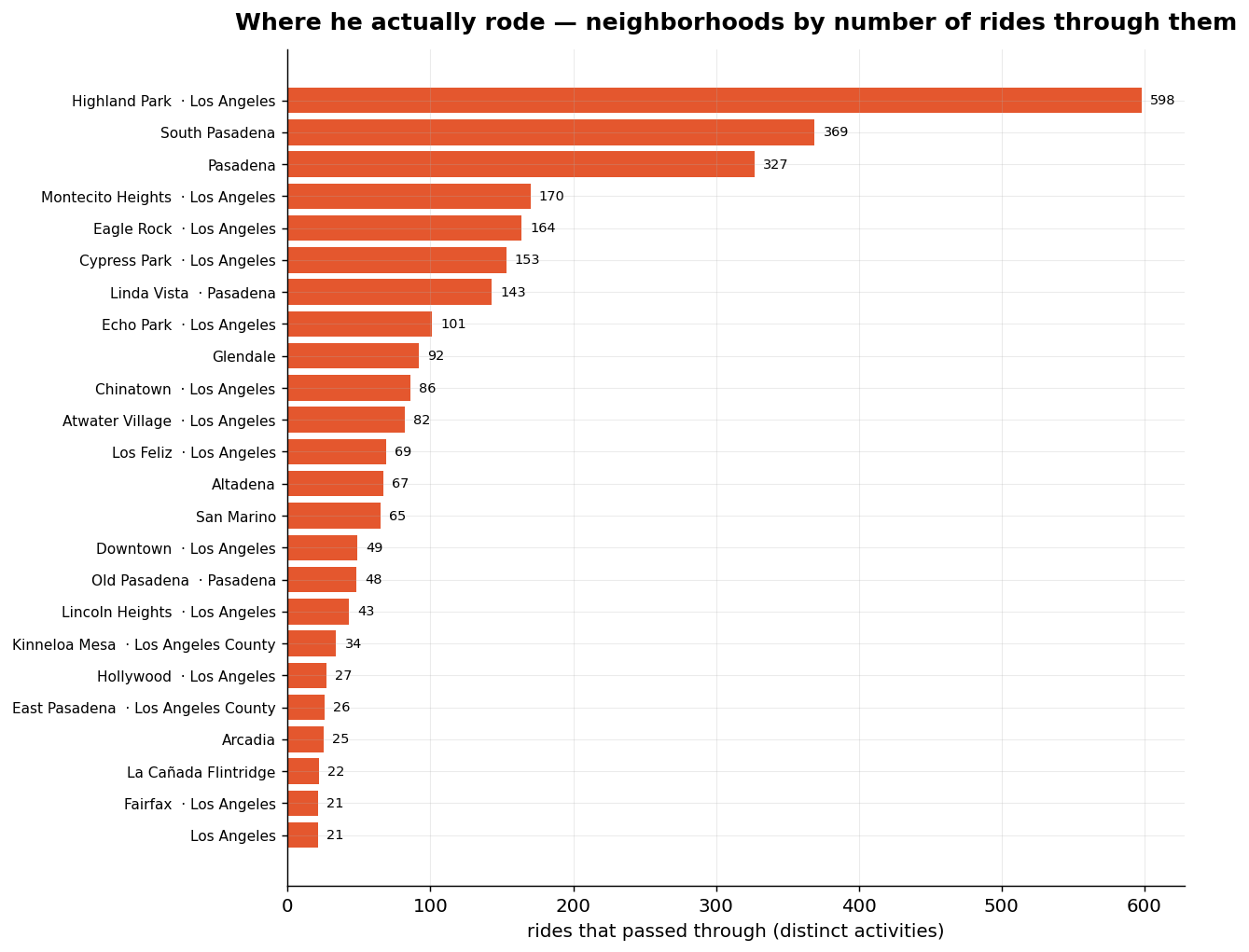
| Neighborhood | Rides through | Neighborhood | Rides through | |
|---|---|---|---|---|
| Highland Park (home) | 598 | Chinatown | 86 | |
| South Pasadena | 369 | Atwater Village | 82 | |
| Pasadena | 327 | Los Feliz | 69 | |
| Montecito Heights | 170 | Altadena | 67 | |
| Eagle Rock | 164 | San Marino | 65 | |
| Cypress Park | 153 | Downtown LA | 49 | |
| Linda Vista | 143 | Old Pasadena | 48 | |
| Echo Park | 101 | Lincoln Heights | 43 | |
| Glendale | 92 | Sierra Madre · Arcadia · Alhambra | ~21 each |
The texture of these rides is pure neighborhood life. The phrases that recur in his own ride logs aren't intervals or threshold — they're farmers market, El Super (the grocery run), Triple Beam (the pizza place), the bike oven (where he volunteered Sundays), and the spin "to station." This is a man who dissolved the line between a bike ride and an errand — as he put it himself, "the lines between a bike ride and the rest of life are beginning to blur." The data agrees: his geography is the geography of a life, not a training plan.
The map filling in — and then a blank map again
Reduce every ride to the set of 1 km² tiles it touched, and you can watch his world expand tile by tile. He covered 2,434 distinct square kilometers in two and a half years — and the rate of new ground tells the whole emotional arc.
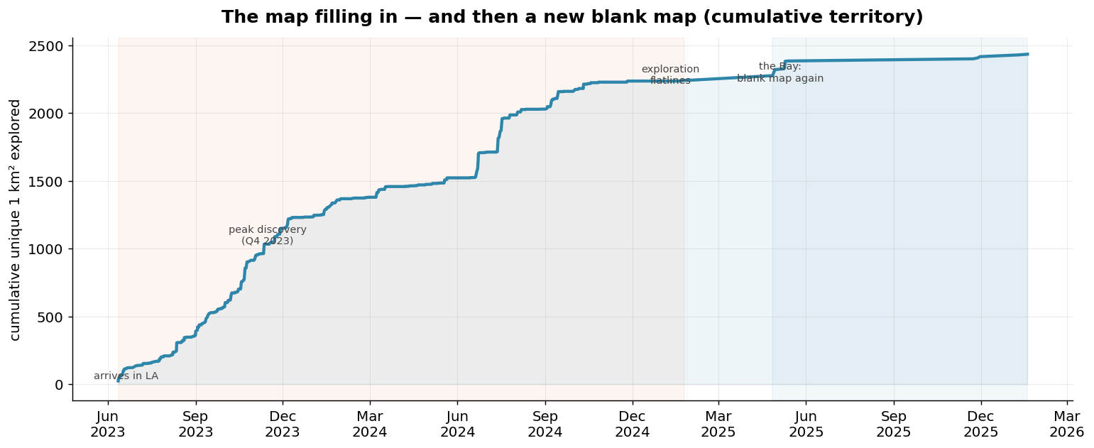
The curve climbs almost vertically through the back half of 2023 — a newcomer's infatuation, devouring new streets — then bends as the map saturates, flatlines through early 2025, and finally adds one small new patch in the Bay. Broken into quarters, the discovery rate is stark:
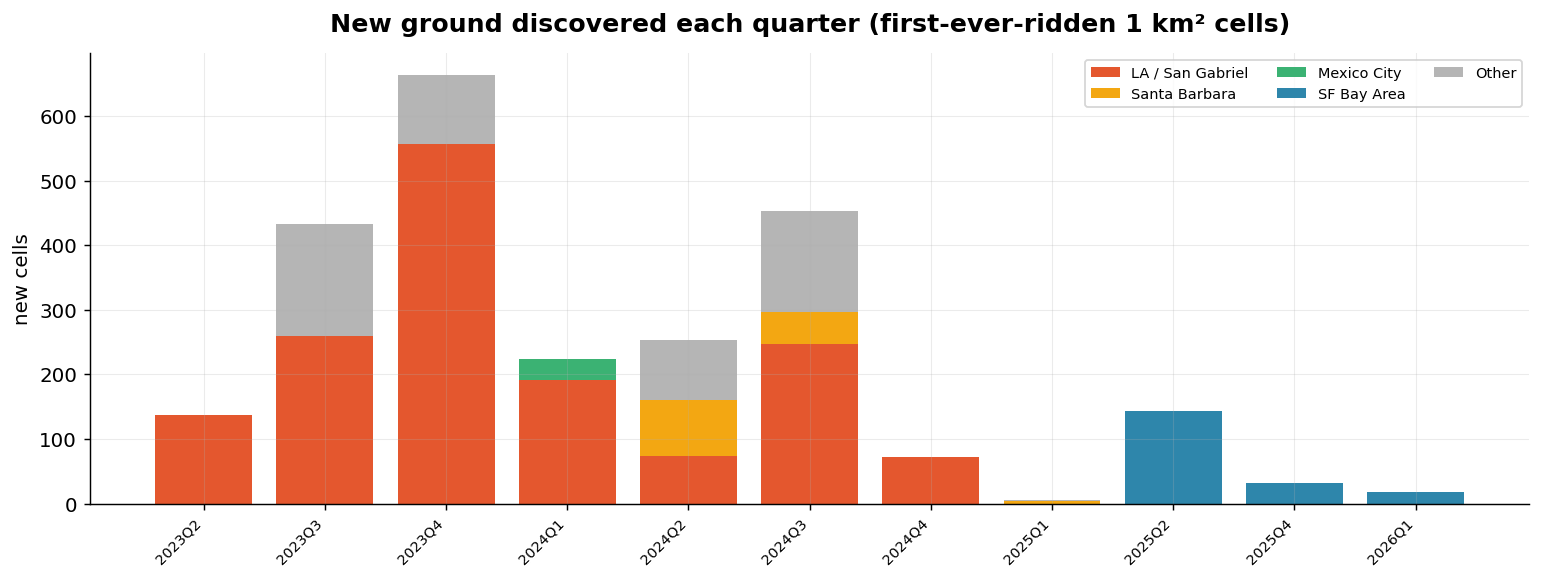
- Summer–Fall 2023: the land rush. 137 new tiles on arrival (Q2), then 433, then a peak 664 new tiles in Q4 2023 — he was exploring faster than at any other time in the record.
- 2024: still finding things, but slower — 224 / 253 / 453 / 72 new tiles per quarter. The mid-year bump is travel (the Santa Barbara trips added a whole new coastline).
- Q1 2025: 5 tiles. Effectively zero. After eighteen months he had ridden essentially everywhere he was going to ride in LA. There was no map left to fill — and within weeks he was gone.
- The Bay (Q2 2025 on): a blank map again — 143 new tiles, then a trickle. A new city to start over in, and almost no riding with which to explore it.
What he found, and when
The discovery order is its own portrait. In his first six days on the bike (June 11–16, 2023) he had already ridden through Highland Park, South Pasadena, Pasadena, Altadena, San Marino, Eagle Rock, Echo Park, Cypress Park, and Montecito Heights — his entire core territory, mapped in a week. The infatuation was immediate and total.
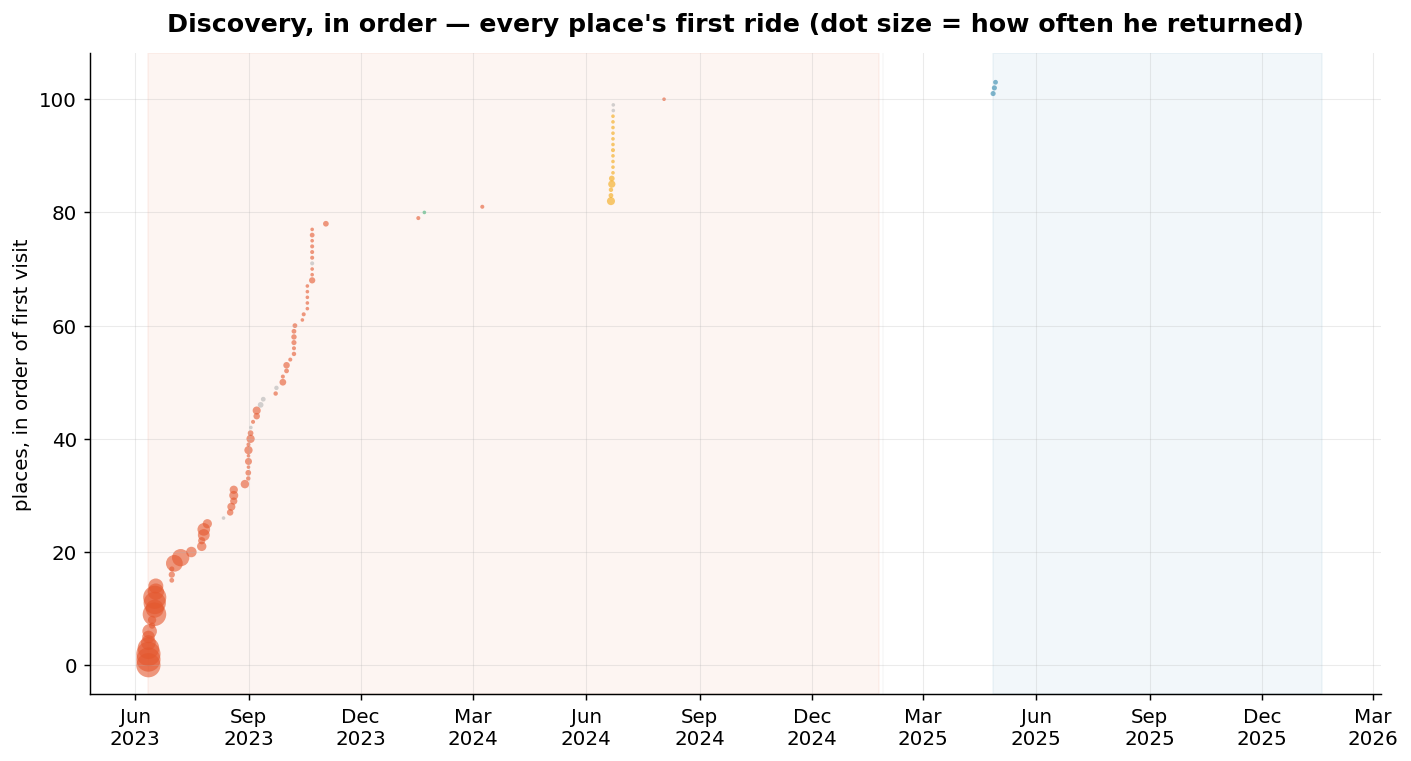
And the other end of the telescope is just as telling: the last genuinely new LA neighborhood he ever discovered was Signal Hill, on August 3, 2024 — a lone dot far south in Long Beach, ridden three times. After that, for his final half-year in Los Angeles, he discovered nothing new. He wasn't exploring anymore; he was revisiting. The map was full.
Favorite roads — the same loop, again and again
If you cluster rides by geometric similarity — rides that trace nearly the same path — the repeats that surface are not the epic mountain days. They're the small, devoted, utterly human loops of a life lived by bike.
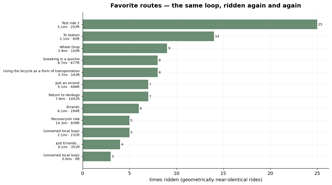
His single most-repeated route is a ~5-mile errand loop through South Pasadena ridden 25 times — its rides are named "South pas farmers market," "Deb's dirt lunch," "Test ride." Just behind it: a 2-mile spin he did 14 times ("To station," "Triple beam recovery" — runs to the local pizza place and the Gold Line), nine runs to the bike shop ("Wheel Drop / Wheel pickup"), and a string of grocery-and-errand loops ("Using the bicycle as a form of transportation," "El super run," "Some late errands"). The bike wasn't separate from his life; it was his transportation, his errands, his afternoons.
The one athletic route that made the favorites list is Verdugo Peak, climbed 7 times ("Return to Verdugo," "Friday Night at Verdugo Peak") — a steep 1,400-foot grind he kept coming back to. The bigger mountains don't appear here for a revealing reason: he climbed them too, often, but never the same way twice — every Mt Wilson or Angeles Crest day took a different approach, so they don't cluster as repeated routes. They were destinations, not routines.
Use his interactive map below to trace the most-repeated loops:
The high points — where the rides were actually going
A route describes the path; but most rides had a point — a summit, a viewpoint, a range to go play in. To find them I counted, for every named high point in his territory, how many of his rides actually passed through it. These are the places his wheels kept returning to.
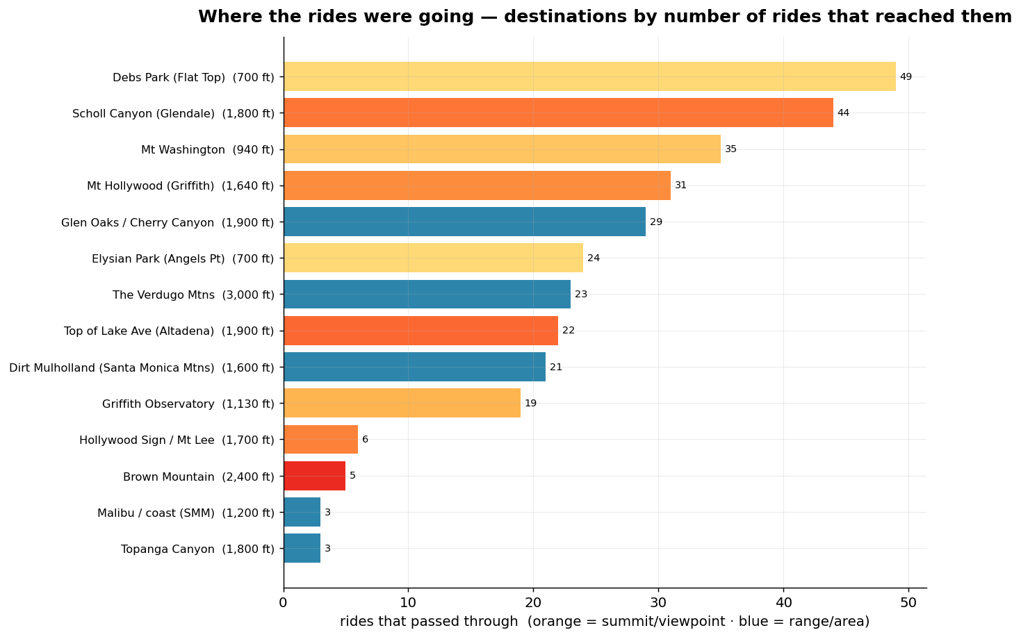
Debs Park's Flat Top (49 rides) and Scholl Canyon in Glendale (44) top the list — the close, repeatable climbs he could bag on an ordinary afternoon. Then Mt Washington (35), Mt Hollywood in Griffith Park (31), the Glen Oaks / Cherry Canyon foothills (29), and Elysian Park's Angels Point (24). Reaching further out: the Verdugo Mountains — 23 rides — the big range across the valley, his highest regular playground at ~3,000 ft; the top of Lake Avenue above Altadena (22); and dirt Mulholland in the Santa Monica Mountains (21) — a gravel world clear across the city, and proof that his range wasn't only the San Gabriels. The rare trophies round it out: the Hollywood Sign at Mt Lee (6), Brown Mountain (5), and the long western reaches to Topanga and Malibu (3 rides each).
The map makes the compass legible. A dense knot of near-home summits in Northeast LA — Debs, Mt Washington, Elysian — minutes from the front door; the Griffith Park crowns to the west; the San Gabriel front range stepping north into Altadena, Henninger Flats and Brown Mountain; the Verdugos across the valley; and — a world away — the dirt of the Santa Monica Mountains, Topanga and Malibu out at the edge of the coast. He didn't have one mountain. He had a whole compass rose of them, and over two years he rode out to all of it.
The Bay, in a handful of neighborhoods
When he restarted in the Bay Area, the contrast is total. Across all 15 Bay rides he touched only a scatter of disconnected areas — the Mission, SoMa, and the Richmond District in San Francisco; Marin County; West Oakland; Berkeley; even down to Santa Clara — no two of them adding up to a routine. Where Los Angeles was 598 rides funneling through a single home block, the Bay is fifteen rides spread across six unconnected corners of a whole region: no doorstep, no loop ridden twice, no neighborhood that ever became his. He had a brand-new map — and almost no riding with which to draw on it. The map never got the chance to fill in.
Method & honest limits
Built on the same pipeline as the first report. Every ride's GPS track was reduced to the 1 km² tiles it touched; tiles were reverse-geocoded to neighborhoods via OpenStreetMap's Nominatim (the most-visited tiles geocoded exactly, the sparse exploration tail filled from nearest named neighbors — so headline neighborhood counts are solid and the long tail is approximate). A "visit" means a distinct ride passed through that place — so his home neighborhood scores near-total because he started there. "Favorite routes" are geometric clusters of near-identical rides (≈300 m resolution, ≥3 repeats); short loops from a shared doorstep cluster more tightly than big mountain days that varied their approach, which biases favorites toward the local and the repeated — exactly the bread-and-butter riding this report is about. Neighborhood labels come from OSM and occasionally read as administrative districts; obvious artifacts were normalized to common names.
Caveats specific to this view: the Bay era is only 15 rides, so its geography is a sketch, not a census; reverse-geocoding is imperfect at tile edges; and "favorite" here means "most repeated," which rewards habit over love — the ride he did once and never forgot doesn't show up in a frequency count.